
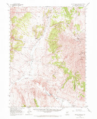
1961 Map of Delano Mountains
USGS Topo · Published 1963About this map
Delno Mines and the Gold Note Mine anchor the northern reaches of the Delano Mountains, where mining operations are etched into the high desert landscape alongside a network of jeep trails. In the early 1960s, this area of Elko County was defined by its scattered ranching outposts and essential water sources, such as the Twentyone Mile Ranch and Eighteenmile Ranch. These settlements relied on the drainage of Thousand Springs Creek and the Twentyone Mile Dam to sustain life in the arid basin. To the west, Ninemile Ridge and Tony Mountain frame a series of rugged corridors including Corral Canyon and Texas Canyon, while the high point of Delano Peak overlooks the historical tracks of the Emigrant Sprs.
Find a feature on this map
40 named features on this map. Tap any name to fly to it.
Don’t see what you’re looking for? This feature index may not catch every label — zoom into the map to look around manually.
Map Details
Editions of this 1961 Delano Mountains Map
2 editions found
Other maps of this area

1955 · Wells
USGS Topo · 1:250,000

1957 · Delaplain
USGS Topo · 1:62,500

1958 · Wells
USGS Topo · 1:250,000

1961 · Wells
USGS Topo · 1:250,000

1961 · Gollaher Mountain
USGS Topo · 1:62,500

1961 · Goose Creek
USGS Topo · 1:62,500

1961 · Dairy Valley
USGS Topo · 1:62,500

1967 · Twelvemile Ranch
USGS Topo · 1:24,000

1967 · Ninemile Mtn NE
USGS Topo · 1:24,000

1967 · Ninemile Mtn
USGS Topo · 1:24,000