
1967 Map of Ninemile Mtn
USGS Topo · Published 1971About this map
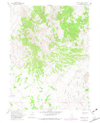
Ninemile Mountain dominates this high-altitude landscape in northeastern Elko County, providing a clear picture of the remote drainage systems and water sources used in the late 1960s. The terrain is defined by its arid character, where essential water points like Hidden Well and Fivemile Draw Well are mapped alongside the seasonal Twentyone Mile Draw. This 1967 field survey illustrates the minimal human infrastructure present at the time, consisting primarily of a Jeep Trail network and isolated landmarks such as a Water Tank and a short segment of an Aqueduct near Kane Canyon. The absence of developed roads emphasizes the area's isolation, serving as a primary source for researchers tracking historic land use, grazing infrastructure, and high-desert navigation routes.
Find a feature on this map
11 named features on this map. Tap any name to fly to it.
Don’t see what you’re looking for? This feature index may not catch every label — zoom into the map to look around manually.
Map Details
Editions of this 1967 Ninemile Mtn Map
2 editions found
Other maps of this area

1955 · Wells
USGS Topo · 1:250,000

1958 · Wells
USGS Topo · 1:250,000

1961 · Wells
USGS Topo · 1:250,000

1961 · Delano Mountains
USGS Topo · 1:62,500

1967 · Montello Canyon
USGS Topo · 1:24,000

1967 · Ninemile Mtn NE
USGS Topo · 1:24,000

1967 · Ninemile Mtn SW
USGS Topo · 1:24,000

1968 · Knoll Mountain SE
USGS Topo · 1:24,000

1968 · Wine Cup Ranch SE
USGS Topo · 1:24,000
1968 · Wine Cup Ranch NE
USGS Topo · 1:24,000