
1967 Map of Montello Canyon
USGS Topo · Published 1971About this map
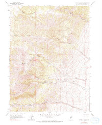
Montello Canyon and its network of spring-fed drainages define this stretch of northeastern Elko County. The landscape is characterized by a series of prominent canyons, including Kane Canyon, Charley Canyon, and Immigrant Canyon, which collect seasonal runoff and spring water. In this high desert environment, water sources were critical for local movement and livestock, as evidenced by the labeling of Montello Springs, Hoppie Basin Spring, and a Ridge Well. This 1967 field-checked survey shows a network of unnamed jeep trails navigating the basins, reflecting the era's reliance on rugged transportation for ranching or prospecting. The naming of Wildhorse Canyon and Gamble Canyon suggests a historical connection to local fauna and early land use, while Charley Creek and Hoppie Creek drain the eastern slopes toward the basin floor.
Find a feature on this map
18 named features on this map. Tap any name to fly to it.
Don’t see what you’re looking for? This feature index may not catch every label — zoom into the map to look around manually.
Map Details
Editions of this 1967 Montello Canyon Map
2 editions found
Other maps of this area

1955 · Wells
USGS Topo · 1:250,000

1958 · Wells
USGS Topo · 1:250,000

1961 · Wells
USGS Topo · 1:250,000

1967 · Valley Pass
USGS Topo · 1:24,000

1967 · Loray
USGS Topo · 1:24,000

1967 · Twelvemile Ranch
USGS Topo · 1:24,000

1967 · Montello
USGS Topo · 1:24,000

1967 · Ninemile Mtn NE
USGS Topo · 1:24,000
1967 · Pilot Peak NW
USGS Topo · 1:24,000

1967 · Ninemile Mtn SW
USGS Topo · 1:24,000