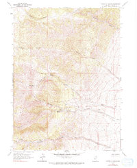
1967 Map of Montello Canyon
USGS Topo · Published 1990About this map
Montello Canyon and its surrounding drainage systems dominate this Elko County landscape, reflecting the essential role of water management in the Great Basin. This mid-century survey documents a network of isolated water sources such as Montello Springs, Hoppie Basin Spring, and Hoppie Basin Well, which likely served as critical stops for livestock and early travelers. The presence of Immigrant Canyon suggests a historical corridor used by westward-moving parties, while a series of named ravines like Wildhorse Canyon, Charley Canyon, and Gamble Canyon carve through the high-elevation terrain. A singular Jeep Trail provides the only recorded access through Hoppie Basin, emphasizing the sparse development and utilitarian nature of the land at the time of the survey.
Find a feature on this map
18 named features on this map. Tap any name to fly to it.
Don’t see what you’re looking for? This feature index may not catch every label — zoom into the map to look around manually.
Map Details
Editions of this 1967 Montello Canyon Map
2 editions found
Other maps of this area

1955 · Wells
USGS Topo · 1:250,000

1958 · Wells
USGS Topo · 1:250,000

1961 · Wells
USGS Topo · 1:250,000

1967 · Valley Pass
USGS Topo · 1:24,000

1967 · Loray
USGS Topo · 1:24,000

1967 · Montello Canyon
USGS Topo · 1:24,000

1967 · Twelvemile Ranch
USGS Topo · 1:24,000

1967 · Montello
USGS Topo · 1:24,000

1967 · Ninemile Mtn NE
USGS Topo · 1:24,000
1967 · Pilot Peak NW
USGS Topo · 1:24,000