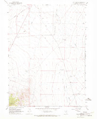
1967 Map of Pilot Peak NW
USGS Topo · Published 1971About this map
The Southern Pacific railroad cuts through the high desert of Elko County, anchoring the small siding of Loray against the stark basin and range topography. This 1967 survey documents a landscape defined by the search for water and minerals, where the Tecoma Valley and Pilot Creek Valley meet the rising slopes of the Toano Range. A scattered network of vital water sources, including the Noble Well 5148, Montello Well No 1, and the Highway Well No 78 (Dry), illustrates the logistical challenges of this arid environment during the late 1960s. At the southern edge, a single Mine and various gravel pits indicate the area's geological utility, while a lone Radio Facility and a complex Aqueduct system represent the mid-century infrastructure supporting the remote northeast corner of Nevada.
Find a feature on this map
21 named features on this map. Tap any name to fly to it.
Don’t see what you’re looking for? This feature index may not catch every label — zoom into the map to look around manually.
Map Details
Editions of this 1967 Pilot Peak NW Map
2 editions found
Other maps of this area

1955 · Wells
USGS Topo · 1:250,000

1958 · Wells
USGS Topo · 1:250,000

1961 · Wells
USGS Topo · 1:250,000

1967 · Pilot Peak
USGS Topo · 1:24,000

1967 · Loray
USGS Topo · 1:24,000

1967 · Montello Canyon
USGS Topo · 1:24,000

1967 · Patterson Pass
USGS Topo · 1:24,000

1967 · Montello
USGS Topo · 1:24,000
1967 · Pilot Peak SW
USGS Topo · 1:24,000
1967 · Tecoma
USGS Topo · 1:24,000