
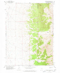
1967 Map of Patterson Pass
USGS Topo · Published 1971About this map
The high desert borderlands of Nevada and Utah are defined here by the sharp ascent of the Pilot Range, a landscape marked by isolated mining prospects and vital water sources in the late 1960s. Mining activity is concentrated in the northern canyons, including Alley Canyon, Regulator Canyon, and near Copper Mtn, where multiple Mines and a Prospect are noted. These extraction sites are linked by primitive routes and a Trail system that traverses the steep terrain of Mcinty Ridge and Patterson Pass.
Find a feature on this map
25 named features on this map. Tap any name to fly to it.
Don’t see what you’re looking for? This feature index may not catch every label — zoom into the map to look around manually.
Map Details
Editions of this 1967 Patterson Pass Map
2 editions found
Other maps of this area

1954 · Brigham City
USGS Topo · 1:250,000

1955 · Wells
USGS Topo · 1:250,000

1958 · Wells
USGS Topo · 1:250,000

1958 · Brigham City
USGS Topo · 1:250,000

1961 · Wells
USGS Topo · 1:250,000

1962 · Brigham City
USGS Topo · 1:250,000

1967 · Pilot Peak
USGS Topo · 1:24,000

1967 · Lucin
USGS Topo · 1:24,000

1967 · Montello
USGS Topo · 1:24,000
1967 · Pilot Peak NW
USGS Topo · 1:24,000