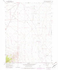
1967 Map of Pilot Peak NW
USGS Topo · Published 1983About this map
The Southern Pacific railroad corridor defines the northwestern corner of this high-desert landscape, passing through the siding at Loray. This 1967 survey captures a remote section of the eastern Nevada basin, where the Tecoma Valley and Pilot Valley meet. The geography is characterized by essential water-access points in an arid environment, including Immigrant Cr, Noble Well, and several facilities such as Montello Well No 1. An Aqueduct system traces a significant path across the valley floor, highlighting the infrastructure required to manage resources in Elko County.
Find a feature on this map
24 named features on this map. Tap any name to fly to it.
Don’t see what you’re looking for? This feature index may not catch every label — zoom into the map to look around manually.
Map Details
Editions of this 1967 Pilot Peak NW Map
2 editions found
Other maps of this area

1955 · Wells
USGS Topo · 1:250,000

1958 · Wells
USGS Topo · 1:250,000

1961 · Wells
USGS Topo · 1:250,000

1967 · Pilot Peak
USGS Topo · 1:24,000

1967 · Loray
USGS Topo · 1:24,000

1967 · Montello Canyon
USGS Topo · 1:24,000

1967 · Patterson Pass
USGS Topo · 1:24,000

1967 · Montello
USGS Topo · 1:24,000
1967 · Pilot Peak NW
USGS Topo · 1:24,000
1967 · Pilot Peak SW
USGS Topo · 1:24,000