
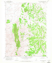
1968 Map of Wine Cup Ranch SE
USGS Topo · Published 1972About this map
Windermere Hills dominate the western landscape of this Elko County interior in the late 1960s, giving way to the broad alluvial passage of Toano Draw. This arid high-desert terrain is defined by its water and industrial infrastructure, where intermittent drainages like Medicine Creek and Deadman Creek carve through the basin floor. The human footprint is sparse but functional, centered on remote water sources such as Toano Well No 1 and Toano Well No 2, and a solitary Oil Well in the northern reaches. Surveyed in 1967 and 1968, the map illustrates the utilitarian nature of the Great Basin during this era, marked by numerous Borrow Pits and a winding Jeep Trail that provided the primary access through the desert. These features suggest a landscape managed for ranching and resource extraction, where every named well and drainage served as a critical landmark for navigation and survival.
Find a feature on this map
11 named features on this map. Tap any name to fly to it.
Don’t see what you’re looking for? This feature index may not catch every label — zoom into the map to look around manually.
Map Details
Editions of this 1968 Wine Cup Ranch SE Map
This is the sole edition of this map. No revisions or reprints were ever made.
Other maps of this area

1955 · Wells
USGS Topo · 1:250,000

1958 · Wells
USGS Topo · 1:250,000

1961 · Wells
USGS Topo · 1:250,000

1967 · Valley Pass
USGS Topo · 1:24,000

1967 · Ninemile Mtn SW
USGS Topo · 1:24,000

1967 · Ninemile Mtn
USGS Topo · 1:24,000

1968 · Holborn
USGS Topo · 1:24,000

1968 · Pequop
USGS Topo · 1:24,000

1968 · Wine Cup Ranch
USGS Topo · 1:24,000
1968 · Wine Cup Ranch SW
USGS Topo · 1:24,000