
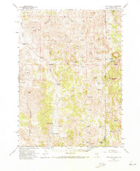
1961 Map of Dairy Valley
USGS Topo · Published 1963About this map
Dairy Valley and the small settlement of Dairy anchor this high-desert landscape during the early 1960s, a period defined by ranching and remote mountain pass routes. Situated along the boundary between Elko County and Box Elder County, the terrain is marked by a network of springs and canyons essential for sustaining the local livestock industry. Landmarks like Toms Cabin and Signboard Pass highlight the sparse human footprint in this corner of the Great Basin, where movement relied on a system of jeep trails and historic paths. Water management is central to the area's layout, evidenced by the Death Creek Reservoir and Granite Creek Reservoir, which capture runoff from the surrounding peaks. The topography transitions from The Baldies in the west to the deeply etched Narrows of Dairy Valley Creek, providing a clear record of the watershed before modern developments altered these rural Nevada and Utah borderlands.
Find a feature on this map
60 named features on this map. Tap any name to fly to it.
Don’t see what you’re looking for? This feature index may not catch every label — zoom into the map to look around manually.
Map Details
Editions of this 1961 Dairy Valley Map
2 editions found
Other maps of this area

1954 · Brigham City
USGS Topo · 1:250,000

1955 · Wells
USGS Topo · 1:250,000

1958 · Wells
USGS Topo · 1:250,000

1958 · Brigham City
USGS Topo · 1:250,000

1959 · Cotton Thomas Basin
USGS Topo · 1:62,500

1961 · Wells
USGS Topo · 1:250,000

1961 · Delano Mountains
USGS Topo · 1:62,500

1961 · Gollaher Mountain
USGS Topo · 1:62,500

1961 · Goose Creek
USGS Topo · 1:62,500

1962 · Brigham City
USGS Topo · 1:250,000