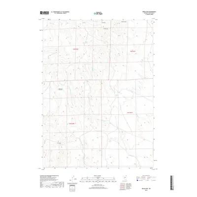
2018 Map of Devils Pass
USGS Topo · Published 2018About this map
Gollaher Mtn and the southern reaches of the Toana John Mountains define this high-elevation corner of Elko County, where the landscape is marked by a network of drainage draws and intermittent water sources. The namesake Devils Pass serves as a critical geographic transition point, situated near the headwaters of Devils Cr. The map reveals a reliance on isolated water points in this arid terrain, with labels for Moonshine Spring, Crocket Spring, and Boulder Spring providing essential markers for travelers and ranchers. This 2018 survey detail shows how the land is partitioned into township and range blocks, such as t46n r66e and t45n r67e, while tracking the paths of Willow Cr and Badger Cr as they cut through the mountain draws.
Find a feature on this map
18 named features on this map. Tap any name to fly to it.
Don’t see what you’re looking for? This feature index may not catch every label — zoom into the map to look around manually.
Map Details
Editions of this 2018 Devils Pass Map
This is the sole edition of this map. No revisions or reprints were ever made.
Other maps of this area

1955 · Wells
USGS Topo · 1:250,000

1957 · Delaplain
USGS Topo · 1:62,500

1958 · Wells
USGS Topo · 1:250,000

1961 · Wells
USGS Topo · 1:250,000

1961 · Delano Mountains
USGS Topo · 1:62,500

1961 · Gollaher Mountain
USGS Topo · 1:62,500

1968 · Texas Spring
USGS Topo · 1:24,000
1980 · Dry Canyon
USGS Topo · 1:24,000

1982 · Jackpot
USGS Topo · 1:100,000
1989 · Stratton Spring
USGS Topo · 1:24,000