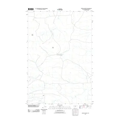
2011 Map of Devils Pocket
USGS Topo · Published 2011About this map
Devils Pocket and the surrounding high plains of Wheatland County define this expansive landscape in the early twenty-first century. The map reveals a remote ranching and grazing environment where water management is critical for land use. Significant infrastructure like Cinnamon Number 2 Dam and Griffith Dam illustrate the efforts to capture seasonal runoff in this arid region, providing water for livestock or local agriculture. The topography is marked by distinctive landforms such as Wild Horse Butte, while the drainage patterns of Timber Creek and Fish Creek carve through the open country. A sparse network of secondary roads, including 12e102s, connects the disparate corners of this territory, reflecting the vast distances and isolated nature of Central Montana rural life.
Find a feature on this map
9 named features on this map. Tap any name to fly to it.
Don’t see what you’re looking for? This feature index may not catch every label — zoom into the map to look around manually.
Map Details
Editions of this 2011 Devils Pocket Map
This is the sole edition of this map. No revisions or reprints were ever made.
Other maps of this area

1889 · Big Snowy Mountain
USGS Topo · 1:250,000

1893 · Big Snowy Mountain
USGS Topo · 1:250,000

1954 · Roundup
USGS Topo · 1:250,000

1958 · Roundup
USGS Topo · 1:250,000

1985 · Jim Creek
USGS Topo · 1:24,000
1985 · Gougley Creek
USGS Topo · 1:24,000

1985 · Progress
USGS Topo · 1:24,000
1986 · Ten O'Clock Gate
USGS Topo · 1:24,000

1986 · Shawmut
USGS Topo · 1:24,000
1986 · Devils Pocket
USGS Topo · 1:24,000