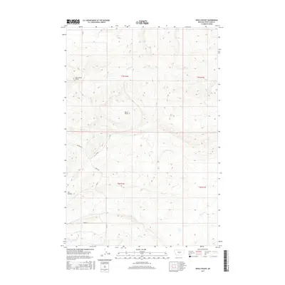
2017 Map of Devils Pocket
USGS Topo · Published 2017About this map
Wild Horse Butte rises above the open high-plains landscape of Wheatland County in this detailed 2017 study. The area is defined by the natural depression of Devils Pocket, a distinctive terrain feature that gives this quadrangle its name. Settlement is sparse in this part of Montana, represented here by the locality known as The Madison. The geography is etched by the drainage patterns of Timber Cr in the north and Fish Cr to the south, which dictate the placement of local thoroughfares like Cooney Rd and Red Bridge Rd. This survey captures a moment in the modern ranching era where public land survey boundaries like t7n r16e and t6n r17e still provide the primary framework for land ownership and movement across the territory.
Find a feature on this map
11 named features on this map. Tap any name to fly to it.
Don’t see what you’re looking for? This feature index may not catch every label — zoom into the map to look around manually.
Map Details
Editions of this 2017 Devils Pocket Map
This is the sole edition of this map. No revisions or reprints were ever made.
Other maps of this area

1889 · Big Snowy Mountain
USGS Topo · 1:250,000

1893 · Big Snowy Mountain
USGS Topo · 1:250,000

1954 · Roundup
USGS Topo · 1:250,000

1958 · Roundup
USGS Topo · 1:250,000

1985 · Jim Creek
USGS Topo · 1:24,000
1985 · Gougley Creek
USGS Topo · 1:24,000

1985 · Progress
USGS Topo · 1:24,000
1986 · Ten O'Clock Gate
USGS Topo · 1:24,000

1986 · Shawmut
USGS Topo · 1:24,000
1986 · Devils Pocket
USGS Topo · 1:24,000