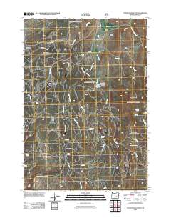
2011 Map of Devine Ridge North
USGS Topo · Published 2011About this map
Devine Ridge and its surrounding ranchlands characterize this high-elevation landscape in Harney County during the early 21st century. The map documents a network of family ranching operations including Purdy Ranch, Nelson Ranch, and Temple Ranch, which are distributed along the drainages of Trout Creek and Strawberry Creek. These settlements are connected by a sparse system of forest service roads like Nat For Dev Rd 3130 and Nat For Dev Rd 3935, reflecting the area's continued reliance on seasonal grazing and timber management.
Find a feature on this map
45 named features on this map. Tap any name to fly to it.
Don’t see what you’re looking for? This feature index may not catch every label — zoom into the map to look around manually.
Map Details
Editions of this 2011 Devine Ridge North Map
This is the sole edition of this map. No revisions or reprints were ever made.
Other maps of this area

1955 · Burns
USGS Topo · 1:250,000

1958 · Burns
USGS Topo · 1:250,000

1959 · Burns
USGS Topo · 1:250,000

1959 · West Myrtle Butte
USGS Topo · 1:62,500

1959 · Harney
USGS Topo · 1:62,500

1960 · Burns
USGS Topo · 1:62,500

1961 · Calamity Butte
USGS Topo · 1:62,500

1978 · Stinkingwater Mountains
USGS Topo · 1:100,000
1990 · Poison Creek
USGS Topo · 1:24,000
1990 · Calamity Butte
USGS Topo · 1:24,000