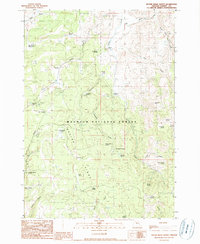
1990 Map of Devine Ridge North
USGS Topo · Published 1990About this map
Malheur National Forest dominates this landscape in Harney County, where the transition from high meadows to steep ridges defines the terrain. The presence of several established homesteads, including Purdy Ranch, Hardesty Ranch, and Dickinson Ranch, indicates a long-standing ranching history in this corner of Oregon. These family-named locations are situated along the drainage of Trout Creek and its many tributaries. The area around Devine Ridge and Marshall Ridge is marked by an extensive network of springs, such as Strawberry Spring and Roach Creek Spring, which have historically supported both livestock and land management activities.
Find a feature on this map
46 named features on this map. Tap any name to fly to it.
Don’t see what you’re looking for? This feature index may not catch every label — zoom into the map to look around manually.
Map Details
Editions of this 1990 Devine Ridge North Map
This is the sole edition of this map. No revisions or reprints were ever made.
Other maps of this area

1955 · Burns
USGS Topo · 1:250,000

1958 · Burns
USGS Topo · 1:250,000

1959 · Burns
USGS Topo · 1:250,000

1959 · West Myrtle Butte
USGS Topo · 1:62,500

1959 · Harney
USGS Topo · 1:62,500

1960 · Burns
USGS Topo · 1:62,500

1961 · Calamity Butte
USGS Topo · 1:62,500

1978 · Stinkingwater Mountains
USGS Topo · 1:100,000
1990 · Poison Creek
USGS Topo · 1:24,000
1990 · Calamity Butte
USGS Topo · 1:24,000