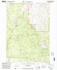
1999 Map of Devine Ridge North
USGS Topo · Published 2002About this map
Malheur National Forest dominates this landscape, where the rugged topography of Devine Ridge meets high-elevation meadows and flats. Grounded in a ranching and forestry economy at the turn of the millennium, the map depicts isolated outposts like Hardesty Ranch, Nelson Ranch, and Dickinson Ranch, alongside the Crow Flat Guard Station. The presence of Williams Field and a Communication Tower near the ridge peak suggests the area's continued role in regional logistics and monitoring.
Find a feature on this map
56 named features on this map. Tap any name to fly to it.
Don’t see what you’re looking for? This feature index may not catch every label — zoom into the map to look around manually.
Map Details
Editions of this 1999 Devine Ridge North Map
This is the sole edition of this map. No revisions or reprints were ever made.
Other maps of this area

1955 · Burns
USGS Topo · 1:250,000

1958 · Burns
USGS Topo · 1:250,000

1959 · Burns
USGS Topo · 1:250,000

1959 · West Myrtle Butte
USGS Topo · 1:62,500

1959 · Harney
USGS Topo · 1:62,500

1960 · Burns
USGS Topo · 1:62,500

1961 · Calamity Butte
USGS Topo · 1:62,500

1978 · Stinkingwater Mountains
USGS Topo · 1:100,000
1990 · Poison Creek
USGS Topo · 1:24,000
1990 · Calamity Butte
USGS Topo · 1:24,000