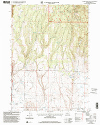
1999 Map of Devine Ridge South
USGS Topo · Published 2002About this map
Malheur National Forest lands dominate the northern topography of this survey, where the high terrain of Devine Ridge slopes down toward the alluvial expanses of the Harney Valley. The landscape is defined by its water resources, with numerous named points such as Widow Spring, Devine Ridge Spring, and Soldier Spring providing critical water in a largely arid environment. These springs often mark the heads of drainages like Byrd Canyon and Soldier Creek, illustrating the natural drainage patterns that have shaped the region's geography.
Find a feature on this map
21 named features on this map. Tap any name to fly to it.
Don’t see what you’re looking for? This feature index may not catch every label — zoom into the map to look around manually.
Map Details
Editions of this 1999 Devine Ridge South Map
This is the sole edition of this map. No revisions or reprints were ever made.
Other maps of this area

1955 · Burns
USGS Topo · 1:250,000

1958 · Burns
USGS Topo · 1:250,000

1959 · Burns
USGS Topo · 1:250,000

1959 · West Myrtle Butte
USGS Topo · 1:62,500

1959 · Harney
USGS Topo · 1:62,500

1960 · Burns
USGS Topo · 1:62,500

1960 · Burns
USGS Topo · 1:24,000

1961 · Calamity Butte
USGS Topo · 1:62,500

1975 · Burns
USGS Topo · 1:24,000

1978 · Stinkingwater Mountains
USGS Topo · 1:100,000