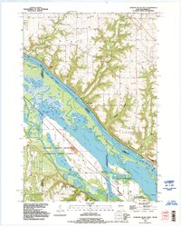
1992 Map of Diamond Bluff West
USGS Topo · Published 1995About this map
The Mississippi River valley at the Wisconsin-Minnesota border is defined here by a sprawling complex of backwaters, sloughs, and islands. In the early 1990s, this reach near Diamond Bluff shows a landscape deeply shaped by both natural alluvial processes and conservation efforts. Much of the river's western flood plain is protected within the Richard J Dorer Memorial Hardwood State Forest, encompassing distinct water bodies like Sturgeon Lake and Sharp Muskrat Lake.
Find a feature on this map
49 named features on this map. Tap any name to fly to it.
Don’t see what you’re looking for? This feature index may not catch every label — zoom into the map to look around manually.
Map Details
Editions of this 1992 Diamond Bluff West Map
This is the sole edition of this map. No revisions or reprints were ever made.
Other maps of this area

1944 · Red Wing
USGS Topo · 1:62,500

1946 · Hudson
USGS Topo · 1:62,500

1946 · River Falls
USGS Topo · 1:62,500

1949 · River Falls
USGS Topo · 1:62,500

1949 · Hudson
USGS Topo · 1:62,500

1951 · Prescott
USGS Topo · 1:24,000

1952 · Red Wing
USGS Topo · 1:62,500

1953 · Saint Paul
USGS Topo · 1:250,000

1957 · Hastings
USGS Topo · 1:62,500

1959 · Saint Paul
USGS Topo · 1:250,000