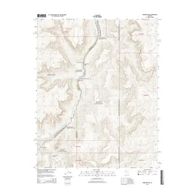
2014 Map of Diamond Peak
USGS Topo · Published 2014About this map
The Colorado River snakes through the Lower Granite Gorge in this northern Arizona landscape, where the high-altitude topography of the Colorado Plateau meets the river's erosive power. This particular section of the canyon is defined by the boundary between Grand Canyon National Park and the Lake Mead National Recreation Area, capturing a wild stretch of water known for its challenging whitewater. Significant navigational landmarks for river travelers include the Two Hundred and Seventeen Mile Rapids and Roadrunner Rapids. On the southern bank, the prominent Diamond Peak rises above the junction where Diamond Cr and Peach Springs Canyon enter the main gorge. The map also delineates the county line between Mohave and Coconino counties, which follows the winding path of the riverbed through Diamond Canyon.
Find a feature on this map
26 named features on this map. Tap any name to fly to it.
Don’t see what you’re looking for? This feature index may not catch every label — zoom into the map to look around manually.
Map Details
Editions of this 2014 Diamond Peak Map
This is the sole edition of this map. No revisions or reprints were ever made.
Other maps of this area

1886 · Diamond Creek
USGS Topo · 1:250,000

1892 · Diamond Creek
USGS Topo · 1:250,000

1948 · Williams
USGS Topo · 1:250,000

1954 · Williams
USGS Topo · 1:250,000

1956 · Williams
USGS Topo · 1:250,000

1960 · Williams
USGS Topo · 1:250,000

1961 · Williams
USGS Topo · 1:250,000
1967 · Hockey Puck Spring
USGS Topo · 1:24,000
1967 · Granite Park
USGS Topo · 1:24,000
1967 · Travertine Rapids
USGS Topo · 1:24,000