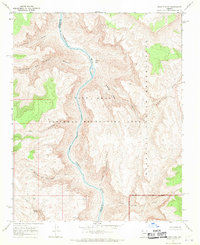
1967 Map of Granite Park
USGS Topo · Published 1970About this map
The Colorado River carves a deep path through northern Arizona, defining the sharp boundary between the Hualapai Indian Reservation and the Lake Mead National Recreation Area. In the late 1960s, this desert landscape was a study in profound verticality, where the river and the southern reach of Lake Mead are hemmed in by massive canyon walls. Evidence of small-scale prospecting and infrastructure appears at the Snyder Mine and the Old Bonnie Tunnel, tucked away in the side canyons. Remote water sources like Three Springs and Stanley Spring suggest the critical points of survival in this arid terrain, while names like Two Hundred and Ninemile Canyon and Two Hundred and Fourteenmile Creek follow the systematic river-mile nomenclature common to this stretch of the Colorado.
Find a feature on this map
21 named features on this map. Tap any name to fly to it.
Don’t see what you’re looking for? This feature index may not catch every label — zoom into the map to look around manually.
Map Details
Editions of this 1967 Granite Park Map
2 editions found
Other maps of this area

1886 · Diamond Creek
USGS Topo · 1:250,000

1886 · Mt. Trumbull
USGS Topo · 1:250,000

1892 · Diamond Creek
USGS Topo · 1:250,000

1892 · Mt. Trumbull
USGS Topo · 1:250,000

1948 · Williams
USGS Topo · 1:250,000

1953 · Grand Canyon
USGS Topo · 1:250,000

1954 · Williams
USGS Topo · 1:250,000

1956 · Williams
USGS Topo · 1:250,000

1957 · Grand Canyon
USGS Topo · 1:250,000

1958 · Grand Canyon
USGS Topo · 1:250,000