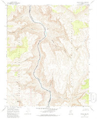
1967 Map of Granite Park
USGS Topo · Published 1986About this map
The Colorado River carves a deep path through this 1967 survey, serving as the primary boundary between Mohave and Coconino counties. The landscape is defined by its extreme topography, where the river meets landmarks like Granite Park and the steep walls of Two Hundred and Ninemile and Indian Canyon. This area represents a point of intersection between Grand Canyon National Park and the Hualapai Indian Reservation, highlighting the administrative and geological complexity of the river corridor.
Find a feature on this map
16 named features on this map. Tap any name to fly to it.
Don’t see what you’re looking for? This feature index may not catch every label — zoom into the map to look around manually.
Map Details
Editions of this 1967 Granite Park Map
2 editions found
Other maps of this area

1886 · Diamond Creek
USGS Topo · 1:250,000

1886 · Mt. Trumbull
USGS Topo · 1:250,000

1892 · Diamond Creek
USGS Topo · 1:250,000

1892 · Mt. Trumbull
USGS Topo · 1:250,000

1948 · Williams
USGS Topo · 1:250,000

1953 · Grand Canyon
USGS Topo · 1:250,000

1954 · Williams
USGS Topo · 1:250,000

1956 · Williams
USGS Topo · 1:250,000

1957 · Grand Canyon
USGS Topo · 1:250,000

1958 · Grand Canyon
USGS Topo · 1:250,000