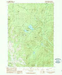
1989 Map of Diamond Pond
USGS Topo · Published 1989About this map
Coleman State Park anchors this late-twentieth-century landscape, spanning the township borders of Stewartstown and Colebrook. The map captures a high-elevation environment dominated by water bodies and prominent ridges, including the namesake Diamond Pond and its smaller neighbor, Little Diamond Pond. Toward the south, Upper Kidderville and Kidderville represent the primary points of settlement along the Mohawk River, while the surrounding terrain is marked by seasonal or sporting outposts such as Old Ramsay Camp and Felton Camp. A network of water systems, including the Swift Diamond River and Nathan Pond Brook, drains the slopes of Sanguinary Mountain and Keazer Mountain. The inclusion of a Snowmobile Trail and a Golf Course near Lake Abeniki reflects the region's mid-to-late century evolution into a hub for outdoor recreation and seasonal residence.
Find a feature on this map
59 named features on this map. Tap any name to fly to it.
Don’t see what you’re looking for? This feature index may not catch every label — zoom into the map to look around manually.
Map Details
Editions of this 1989 Diamond Pond Map
2 editions found
Other maps of this area

1925 · Indian Stream
USGS Topo · 1:48,000

1926 · Indian Stream
USGS Topo · 1:62,500

1927 · Indian Stream
USGS Topo · 1:62,500

1927 · Second Lake
USGS Topo · 1:62,500

1930 · Dixville
USGS Topo · 1:62,500

1930 · Errol
USGS Topo · 1:62,500

1932 · Second Lake
USGS Topo · 1:62,500

1933 · Dixville
USGS Topo · 1:62,500

1934 · Dixville
USGS Topo · 1:62,500

1934 · Errol
USGS Topo · 1:62,500