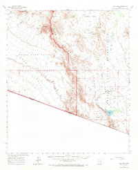
1963 Map of Diaz Peak
USGS Topo · Published 1971About this map
The Organ Pipe Cactus National Monument and the Papago Indian Reservation meet in this arid landscape along the United States-Mexico border. The terrain is defined by the stark verticality of the Ajo Range, featuring landmarks like Diaz Peak and Diaz Spire. Between these heights, expansive lowlands such as Barajita Valley and the Sonoyta Valley provide natural corridors, though water is the primary concern for any inhabitant. The map records critical water sources including Menagers Lake, Blankenship Well, and Adams Well. Human presence is clustered at Ali Chuk, Sweetwater, and Ali Ak Chin, where the presence of a Cem (cemetery) and scattered Jeep Trails suggest the persistent, remote life of Pima County's borderlands. The intricate drainage network of Pia Oik Wash and Sweetwater Wash highlights the seasonal hydrology that has shaped cattle ranching and indigenous settlement patterns in this part of the Sonoran Desert.
Find a feature on this map
36 named features on this map. Tap any name to fly to it.
Don’t see what you’re looking for? This feature index may not catch every label — zoom into the map to look around manually.
Map Details
Editions of this 1963 Diaz Peak Map
2 editions found

Other maps of this area

1953 · Ajo
USGS Topo · 1:250,000

1954 · Sonoyta
USGS Topo · 1:250,000

1957 · Ajo
USGS Topo · 1:250,000

1958 · Ajo
USGS Topo · 1:250,000

1962 · Ajo
USGS Topo · 1:250,000

1963 · Ajo
USGS Topo · 1:250,000

1963 · Kom Vo
USGS Topo · 1:62,500

1963 · Mt. Ajo
USGS Topo · 1:62,500

1963 · Lukeville
USGS Topo · 1:62,500

1963 · Pisinimo
USGS Topo · 1:62,500
Featured Places
- Gu Vo District, AZ
- Ali Ak Chin, Gu Vo District
- Ali Chuk, Gu Vo District
- Sweetwater, Gu Vo District
- Siovi Shuatak, Gu Vo District