
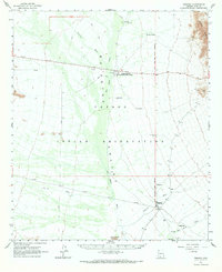
1963 Map of Pisinimo
USGS Topo · Published 1964About this map
The Papago Indian Reservation dominates this 1963 landscape, centered on the broad drainage of the San Simon Wash. The settlement pattern is defined by traditional villages and essential water sources, including the village of Pisinimo and Wahak Hotrontk. The arid terrain is etched by several seasonal watercourses such as Hickman Wash, Gu Vo Wash, and Pisinimo Wash, which converge toward the valley floor. To the east, the topography rises sharply toward the Sierra Blanca mountains. The map documents scattered wells and outposts like North Tracys Well, San Antone Well, and Schuk Cowlik, reflecting the critical importance of water infrastructure for the Tohono O'odham communities in this desert environment during the early 1960s.
Find a feature on this map
27 named features on this map. Tap any name to fly to it.
Don’t see what you’re looking for? This feature index may not catch every label — zoom into the map to look around manually.
Map Details
Editions of this 1963 Pisinimo Map
2 editions found
Other maps of this area

1953 · Ajo
USGS Topo · 1:250,000

1954 · Sonoyta
USGS Topo · 1:250,000

1957 · Ajo
USGS Topo · 1:250,000

1958 · Ajo
USGS Topo · 1:250,000

1962 · Ajo
USGS Topo · 1:250,000

1963 · Ajo
USGS Topo · 1:250,000

1963 · Kom Vo
USGS Topo · 1:62,500

1963 · Sikort Chuapo Mts
USGS Topo · 1:62,500

1963 · Mt. Ajo
USGS Topo · 1:62,500

1963 · Gu Oidak
USGS Topo · 1:62,500
Featured Places
- Gu Vo District, AZ
- Viason Chin, Pisinemo District
- Hickiwan, AZ
- Komak Wuacho, Pisinemo District
- Ahan Owuch, Pisinemo District