
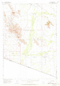
1963 Map of Kom Vo
USGS Topo · Published 1964About this map
Papago Indian Reservation lands dominate this mid-century desert survey, illustrating a landscape defined by seasonal water and cultural heritage. The settlements of Kom Vo, Vamori, and Stan Shuatuk are established near the drainage of San Simon Wash and Vamori Wash, which cut through the broad Quijotoa Valley. The map records specific points of human history and utility, such as Petroglyphs near the Stoa Tontk Well, and a Cem located south of the settlements.
Find a feature on this map
29 named features on this map. Tap any name to fly to it.
Don’t see what you’re looking for? This feature index may not catch every label — zoom into the map to look around manually.
Map Details
Editions of this 1963 Kom Vo Map
2 editions found
Other maps of this area

1953 · Ajo
USGS Topo · 1:250,000

1954 · Sonoyta
USGS Topo · 1:250,000

1957 · Ajo
USGS Topo · 1:250,000

1958 · Ajo
USGS Topo · 1:250,000

1962 · Ajo
USGS Topo · 1:250,000

1963 · Ajo
USGS Topo · 1:250,000

1963 · Mt. Ajo
USGS Topo · 1:62,500

1963 · Gu Oidak
USGS Topo · 1:62,500

1963 · Quijotoa Mts
USGS Topo · 1:62,500

1963 · Pisinimo
USGS Topo · 1:62,500
Featured Places
- Gu Vo District, AZ
- Chukut Kuk District, AZ
- Pisinemo District, AZ
- Kom Vo, Pisinemo District
- Shaotkam, Gu Vo District