
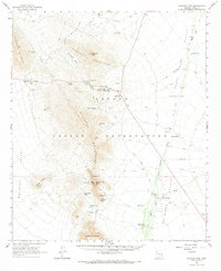
1963 Map of Quijotoa Mts
USGS Topo · Published 1964About this map
The Quijotoa Mountains and the surrounding Papago Indian Reservation define this landscape of the Sonoran Desert in the early 1960s. The map reveals a high concentration of mining activity concentrated near the central peaks, including the Weldon Mine, Quijotoa Mine, and Ben Lomond Mines. Small settlements and seasonal habitations such as Maish Vaya (Covered Wells) and Stoa Vaya (Site) are connected by an intricate network of jeep trails and washes. The reliance on scarce water sources is evident through the labeling of scattered infrastructure like the Old Quijotoa Well (Dry), Brownell Well, and Havana Tank. Dominant landforms like Ben Nevis Mountain and Black Butte rise above the Santa Rosa Valley, providing essential landmarks in an area where the Quijotoa Trading Post once served as a vital regional hub.
Find a feature on this map
50 named features on this map. Tap any name to fly to it.
Don’t see what you’re looking for? This feature index may not catch every label — zoom into the map to look around manually.
Map Details
Editions of this 1963 Quijotoa Mts Map
2 editions found
Other maps of this area

1934 · Silver Bell
USGS Topo · 1:125,000

1937 · Comobabi
USGS Topo · 1:48,000

1941 · Sells
USGS Topo · 1:62,500

1942 · Comobabi
USGS Topo · 1:62,500

1943 · Sells
USGS Topo · 1:62,500

1943 · Fresnal
USGS Topo · 1:125,000

1953 · Ajo
USGS Topo · 1:250,000

1954 · Sonoyta
USGS Topo · 1:250,000

1956 · Nogales
USGS Topo · 1:250,000

1956 · Tucson
USGS Topo · 1:250,000
Featured Places
- Kaihon Kug, Sells
- Maish Vaya, Gu Achi District
- Kui Tatk, Sells
- Narcho Santos, Gu Achi District
- Piato Vaya, Pisinemo District