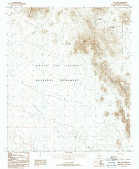
1988 Map of Diaz Peak
USGS Topo · Published 1988About this map
Organ Pipe Cactus National Monument dominates this desert landscape, where the dramatic elevation changes of the Ajo Range create a sharp contrast with the expansive Sonoyta Valley to the south. This 1988 provisional edition captures a transition in the region's topography, marking significant high points like Diaz Peak and the distinctive Diaz Spire. The map illustrates a remote wilderness managed for conservation, yet it remains a place of cultural convergence as the monument's eastern boundary meets the Papago Indian Reservation.
Find a feature on this map
14 named features on this map. Tap any name to fly to it.
Don’t see what you’re looking for? This feature index may not catch every label — zoom into the map to look around manually.
Map Details
Editions of this 1988 Diaz Peak Map
This is the sole edition of this map. No revisions or reprints were ever made.
Other maps of this area

1953 · Ajo
USGS Topo · 1:250,000

1954 · Sonoyta
USGS Topo · 1:250,000

1957 · Ajo
USGS Topo · 1:250,000

1958 · Ajo
USGS Topo · 1:250,000

1962 · Ajo
USGS Topo · 1:250,000

1963 · Ajo
USGS Topo · 1:250,000

1963 · Mt. Ajo
USGS Topo · 1:62,500

1963 · Lukeville
USGS Topo · 1:62,500

1963 · Kino Peak
USGS Topo · 1:62,500

1963 · Lukeville
USGS Topo · 1:250,000