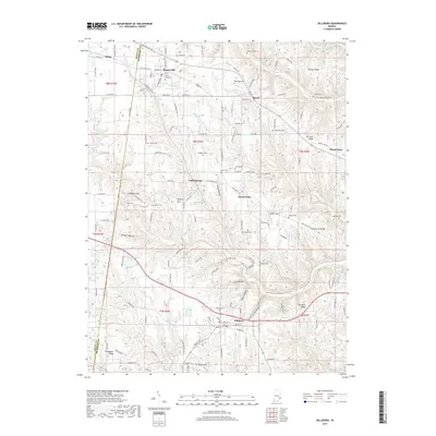
2019 Map of Dillsboro
USGS Topo · Published 2019About this map
Moores Hill and Dillsboro anchor this survey of southeastern Indiana, where the drainage systems of South Hogan Creek and North Hogan Creek carve a complex topography of ridges and hollows. The landscape is defined by its deep genealogical roots, visible in the numerous family and community burial grounds such as Forest Hill Cem, McKinstry Cem, and Oakdale Cem. Transportation is dominated by the CSX Transportation line and historic thoroughfares like the Sparta Pike and Old State Rd 350. The map reveals a high density of named terrain features, from the heights of Holman Ridge and Mt Sinai Ridge to the tucked-away depths of Love Hollow and Possum Hollow. Small settlements like Sparta and Chesterville appear alongside more remote landmarks, including Mt Sinai Church and Lake Hilldear.
Find a feature on this map
71 named features on this map. Tap any name to fly to it.
Don’t see what you’re looking for? This feature index may not catch every label — zoom into the map to look around manually.
Map Details
Editions of this 2019 Dillsboro Map
This is the sole edition of this map. No revisions or reprints were ever made.
Other maps of this area

1915 · Lawrenceburg
USGS Topo · 1:48,000

1928 · Lawrenceburg
USGS Topo · 1:62,500

1932 · Lawrenceburg
USGS Topo · 1:62,500

1943 · Aberdeen
USGS Topo · 1:24,000

1943 · Aurora
USGS Topo · 1:24,000

1943 · Guilford
USGS Topo · 1:24,000

1946 · Milan
USGS Topo · 1:24,000

1946 · Pierceville
USGS Topo · 1:24,000

1953 · Aberdeen
USGS Topo · 1:24,000

1953 · Aurora
USGS Topo · 1:24,000