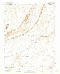
1952 Map of Dinnehotso
USGS Topo · Published 1965About this map
Monument Valley and its iconic sandstone formations dominate the northwest portion of this 1952 survey, which was conducted in cooperation with the Atomic Energy Commission. This collaboration points to the era's industrial interests, specifically the extraction of uranium at the Monument No 2 Mine located on the slopes of Yazzie Mesa. The landscape is defined by the massive uplift of Comb Ridge and Garnet Ridge, which channel drainage toward the Laguna Creek valley. Near the center of the map, the Dinnehotso Trading Post serves as a focal point for local activity, supported by a network of an Irrigation Ditch, a levee, and a dam. Geological landmarks like Rooster Rock, Meridian Butte, and a Natural Arch are meticulously recorded, alongside hydrological features such as Sahotsoidbeazhe Creek and the broad Greasewood Flat.
Find a feature on this map
31 named features on this map. Tap any name to fly to it.
Don’t see what you’re looking for? This feature index may not catch every label — zoom into the map to look around manually.
Map Details
Editions of this 1952 Dinnehotso Map
3 editions found
Other maps of this area

1883 · Marsh Pass
USGS Topo · 1:250,000

1886 · Henry Mountains
USGS Topo · 1:250,000

1886 · Abajo
USGS Topo · 1:250,000

1892 · Marsh Pass
USGS Topo · 1:250,000

1892 · Abajo
USGS Topo · 1:250,000

1892 · Henry Mountains
USGS Topo · 1:250,000

1892 · Canyon De Chelly
USGS Topo · 1:250,000

1893 · Abajo
USGS Topo · 1:250,000

1952 · Bluff 3 SE
USGS Topo · 1:24,000

1952 · Dinnehotso
USGS Topo · 1:62,500