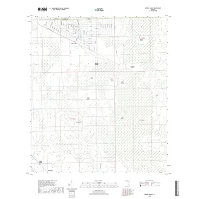
2018 Map of Dinner Island
USGS Topo · Published 2018About this map
Bunnell and the northern reaches of the Big Cypress Swamp define this portion of Flagler County. The landscape is characterized by a complex network of interior islands rising above low-lying wetlands, such as Turkey Island, Bear Island, and Jack O'Neck Island. To the northwest, the settlement of Roy sits near the St. Johns County line, while Andalusia occupies the southwestern corner near the shores of Crescent Lake. Waterways like Sixteenmile Cr and Salt Cr drain the area, which also features significant topographical landmarks like Shell Bluff. The transition from the rural outskirts of Bunnell to the dense swamp environment highlights the historical challenges of settlement and navigation in this region of Florida, where dry land is often fragmented by the reach of the Long Swamp.
Find a feature on this map
74 named features on this map. Tap any name to fly to it.
Don’t see what you’re looking for? This feature index may not catch every label — zoom into the map to look around manually.
Map Details
Editions of this 2018 Dinner Island Map
This is the sole edition of this map. No revisions or reprints were ever made.
Other maps of this area

1912 · Palatka
USGS Topo · 1:48,000

1915 · Palatka
USGS Topo · 1:62,500

1937 · Dinner Island
USGS Topo · 1:48,000

1943 · Dinner Island
USGS Topo · 1:62,500

1944 · Dinner Island
USGS Topo · 1:62,500

1954 · Daytona Beach
USGS Topo · 1:250,000

1956 · Dinner Island NE
USGS Topo · 1:24,000
1957 · Espanola
USGS Topo · 1:24,000

1958 · Daytona Beach
USGS Topo · 1:250,000

1964 · Daytona Beach
USGS Topo · 1:250,000