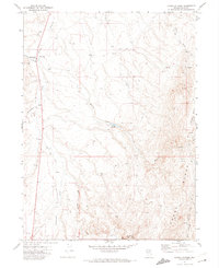
1971 Map of Dinner Station
USGS Topo · Published 1974About this map
Dinner Station sits at the western edge of the Adobe Range, serving as a focal point for this high-desert ranching landscape in northern Nevada. The terrain is defined by a network of seasonal watercourses, including Sixteenmile Creek, Dorsey Creek, and Willow Creek, which flow through the basins and canyons. The presence of a Corral, several Water Tanks, and a series of Borrow Pits highlights the area's utility for livestock and local infrastructure maintenance. Central to the drainage system is the Dorsey Reservoir, positioned below Dorsey Basin to capture runoff. A complex web of Jeep Trails provides the primary means of navigation through the hills, connecting remote springs and family-named landmarks like the East Branch Sherman Creek. This 1971 field-checked survey preserves the layout of these upland grazing lands before modern changes, documenting the location of established wells and springs critical to the region's ranching operations.
Find a feature on this map
16 named features on this map. Tap any name to fly to it.
Don’t see what you’re looking for? This feature index may not catch every label — zoom into the map to look around manually.
Map Details
Editions of this 1971 Dinner Station Map
This is the sole edition of this map. No revisions or reprints were ever made.
Other maps of this area

1955 · Wells
USGS Topo · 1:250,000

1955 · Elko
USGS Topo · 1:250,000

1958 · Wells
USGS Topo · 1:250,000

1958 · Elko
USGS Topo · 1:250,000

1958 · Singletree Creek
USGS Topo · 1:24,000

1958 · Doby Summit
USGS Topo · 1:24,000

1961 · Wells
USGS Topo · 1:250,000

1962 · Elko
USGS Topo · 1:250,000

1962 · Kittridge Springs
USGS Topo · 1:24,000

1962 · Osino
USGS Topo · 1:24,000