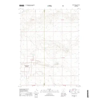
2019 Map of Dipper Spring
USGS Topo · Published 2019About this map
Pawnee National Grassland dominates the western portion of this 2019 survey, illustrating the managed prairie landscape along the border of Weld and Logan Counties. The terrain is defined by a series of intermittent watercourses and draws that drain the high plains, including Sidney Draw in the northwest and Spring Draw in the south. These seasonal drainages are critical to the region's ranching history, as evidenced by the distribution of water sources like Antelope Spring and Dipper Spring.
Find a feature on this map
22 named features on this map. Tap any name to fly to it.
Don’t see what you’re looking for? This feature index may not catch every label — zoom into the map to look around manually.
Map Details
Editions of this 2019 Dipper Spring Map
This is the sole edition of this map. No revisions or reprints were ever made.
Other maps of this area

1954 · Sterling
USGS Topo · 1:250,000

1954 · Scottsbluff
USGS Topo · 1:250,000

1958 · Scottsbluff
USGS Topo · 1:250,000

1958 · Sterling
USGS Topo · 1:250,000

1972 · Potter SW
USGS Topo · 1:24,000

1972 · Kimball SE
USGS Topo · 1:24,000

1972 · Kimball SW
USGS Topo · 1:24,000

1977 · Dipper Spring
USGS Topo · 1:24,000
1977 · Battle Canyon
USGS Topo · 1:24,000

1977 · Avalo SE
USGS Topo · 1:24,000