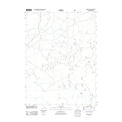
2012 Map of Divide Peak
USGS Topo · Published 2012About this map
Divide Peak and Dexter Peak anchor this high-altitude landscape in Carbon County, Wyoming, as it appeared in the early twenty-first century. The area is defined by the Continental Divide's drainage patterns, where headwaters like N Fork Savery Cr and E Fork Savery Cr begin their descent. Small-scale water management is evident at Twin Groves Reservoir, while the presence of named grazing areas such as Joes Park and McLain Park suggests a history of seasonal high-country ranching. These basins and flats are linked by a network of unimproved roads and the primary artery of Jack Creek Rd, illustrating the intersection of natural resource management and recreational land use. Significant seasonal drainages including Strawberry Cr and Dirtyman Fork carve through the terrain, centering on topographical landmarks like Strawberry Gulch.
Find a feature on this map
22 named features on this map. Tap any name to fly to it.
Don’t see what you’re looking for? This feature index may not catch every label — zoom into the map to look around manually.
Map Details
Editions of this 2012 Divide Peak Map
This is the sole edition of this map. No revisions or reprints were ever made.
Other maps of this area

1932 · Savery
USGS Topo · 1:96,000

1940 · Savery
USGS Topo · 1:125,000

1954 · Rawlins
USGS Topo · 1:250,000

1958 · Rawlins
USGS Topo · 1:250,000

1961 · Divide Peak
USGS Topo · 1:24,000

1961 · Middlewood Hill
USGS Topo · 1:24,000

1961 · Pine Grove Ranch
USGS Topo · 1:24,000

1961 · Bridger Peak
USGS Topo · 1:24,000

1961 · Jack Creek Reservoir
USGS Topo · 1:24,000
1961 · Singer Peak
USGS Topo · 1:24,000