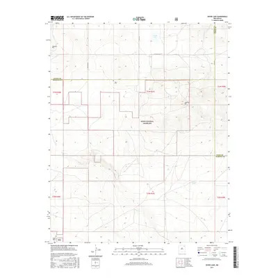
2017 Map of Divine Lake
USGS Topo · Published 2017About this map
The Kiowa National Grassland dominates this high plains landscape at the intersection of Union, Colfax, and Harding counties in northeastern New Mexico. This 2017 survey details the complex system of section lines and rural tracks, such as Sugarloaf Rd and Co Rd C-42, that facilitate movement across the open range. Notable elevation markers like Sugarloaf Mtn and Chateau Hill punctuate the terrain, while the solitary Mofax Cem serves as a small but significant site of local heritage. Water remains a central theme in this arid environment, with ephemeral features like Divine Lake, the Ramon Lakes, and the winding path of Carrizo Cr providing essential drainage. This modern topo allows for the study of how public lands and private ranches are partitioned within the traditional township and range grid.
Find a feature on this map
25 named features on this map. Tap any name to fly to it.
Don’t see what you’re looking for? This feature index may not catch every label — zoom into the map to look around manually.
Map Details
Editions of this 2017 Divine Lake Map
This is the sole edition of this map. No revisions or reprints were ever made.
Other maps of this area

1954 · Raton
USGS Topo · 1:250,000

1954 · Dalhart
USGS Topo · 1:250,000

1958 · Raton
USGS Topo · 1:250,000

1958 · Dalhart
USGS Topo · 1:250,000

1962 · Dalhart
USGS Topo · 1:250,000
1973 · Valencia Spring
USGS Topo · 1:24,000
1974 · Kansas Valley
USGS Topo · 1:24,000

1974 · Farley
USGS Topo · 1:24,000
1974 · Mills East
USGS Topo · 1:24,000

1974 · Spear Hills
USGS Topo · 1:24,000