
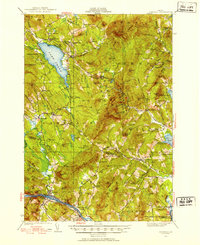
1926 Map of Dixfield
USGS Topo · Published 1953About this map
Lake Webb dominates the northwestern landscape of this Maine interior, its waters framed by steep slopes such as Potter Hill and Rand Ridge. In the valley to the south, the industrial and transport hub of Dixfield sits at the confluence of the Webb River and the Androscoggin River, where the Maine Central railroad tracks follow the river's bend. This 1920s environment is defined by its rural infrastructure, featuring a dense network of country schoolhouses like Maple Grove School and Science Hill School scattered across the upland townships. Evidence of local industry appears at Hildreths Mill along Alder Brook, while numerous small settlements including Berry Mills, Weld, and East Dixfield serve as anchors for the surrounding timber and dairy country. The terrain rises sharply to the east toward the heights of Mt Blue and Spruce Mtn, illustrating the transition from river valley commerce to mountain wilderness.
Find a feature on this map
139 named features on this map. Tap any name to fly to it.
Don’t see what you’re looking for? This feature index may not catch every label — zoom into the map to look around manually.
Map Details
Editions of this 1926 Dixfield Map
2 editions found
Other maps of this area

1910 · Livermore
USGS Topo · 1:62,500

1911 · Bryant Pond
USGS Topo · 1:62,500

1911 · Buckfield
USGS Topo · 1:62,500

1912 · Livermore
USGS Topo · 1:62,500

1913 · Buckfield
USGS Topo · 1:62,500

1914 · Bryant Pond
USGS Topo · 1:62,500

1924 · Farmington
USGS Topo · 1:62,500

1927 · Rumford
USGS Topo · 1:48,000

1929 · Phillips
USGS Topo · 1:48,000

1929 · Dixfield
USGS Topo · 1:62,500