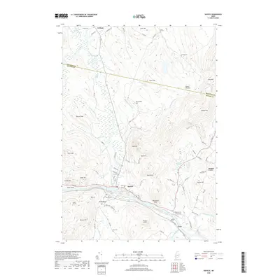
2018 Map of Dixfield
USGS Topo · Published 2018About this map
The Androscoggin River flows through the southern portion of this region, providing the primary geographic corridor for the towns of Peru and Dixfield. This landscape is characterized by a high density of family and community burial grounds, such as the Holman Family Cem, Burgess Hill Cem, and Demerritt Cem, which offer significant value for genealogical research in Oxford County. The confluence of the Webb River and the Androscoggin anchors the settlement at Dixfield, while smaller hamlets like West Peru and Dixfield Center are situated along the valley floor. To the north, the terrain rises into numerous named peaks and ridges, including Storer Hill, Masterman Hill, and the prominent Whittemore Bluff. These uplands are drained by a complex network of streams like Aunt Hannah Brook and Kittredge Brook, illustrating the transition from river-bottom settlements to the timbered heights of the western Maine interior.
Find a feature on this map
85 named features on this map. Tap any name to fly to it.
Don’t see what you’re looking for? This feature index may not catch every label — zoom into the map to look around manually.
Map Details
Editions of this 2018 Dixfield Map
This is the sole edition of this map. No revisions or reprints were ever made.
Other maps of this area

1911 · Bryant Pond
USGS Topo · 1:62,500

1911 · Buckfield
USGS Topo · 1:62,500

1913 · Buckfield
USGS Topo · 1:62,500

1914 · Bryant Pond
USGS Topo · 1:62,500

1926 · Dixfield
USGS Topo · 1:62,500

1927 · Rumford
USGS Topo · 1:48,000

1929 · Dixfield
USGS Topo · 1:62,500

1930 · Rumford
USGS Topo · 1:62,500

1942 · Buckfield
USGS Topo · 1:62,500

1942 · Bryant Pond
USGS Topo · 1:62,500