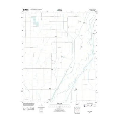
2011 Map of Dixie
USGS Topo · Published 2011About this map
The Saint Francis River winds along the eastern boundary of this landscape, its complex hydrology defining a series of landforms including Big Island, Newton Island, and Rush Island. This area of Northeast Arkansas is characterized by a dense grid of rural routes such as Greene Road 915 and County Rd-998, which connect small agricultural hubs and residential clusters. The map details several historically significant settlements including Dixie, Lester, and Schug, alongside numerous family-named landmarks like Mitchell Point and White Oak Point. Local history is anchored by several burial grounds situated near these communities, notably Parsons Cemetery, Miller Cemetery, and Burrow Cemetery. The transition from the alluvial lowlands near Deasons Lake to the slightly elevated Upper Poplar Ridge illustrates the subtle but critical topography that historically influenced settlement patterns in Craighead and Greene counties.
Find a feature on this map
75 named features on this map. Tap any name to fly to it.
Don’t see what you’re looking for? This feature index may not catch every label — zoom into the map to look around manually.
Map Details
Editions of this 2011 Dixie Map
This is the sole edition of this map. No revisions or reprints were ever made.
Other maps of this area

1939 · Jonesboro
USGS Topo · 1:62,500

1940 · Gainesville
USGS Topo · 1:62,500

1940 · Marmaduke
USGS Topo · 1:62,500

1941 · Leachville
USGS Topo · 1:62,500

1953 · Memphis
USGS Topo · 1:250,000

1956 · Leachville
USGS Topo · 1:62,500

1956 · Memphis
USGS Topo · 1:250,000

1957 · Poplar Bluff
USGS Topo · 1:250,000

1958 · Jonesboro
USGS Topo · 1:62,500

1958 · Marmaduke
USGS Topo · 1:62,500