
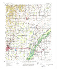
1958 Map of Marmaduke
USGS Topo · Published 1962About this map
Marmaduke and northern Paragould anchor this survey of the St. Francis River basin, where the St Louis Southwestern RR cuts a diagonal path across the drainage network of Greene County. The landscape is defined by an intricate system of sloughs and islands, including Upper Panther Island and Lower Panther Island, shaped by the proximity of the Arkansas Missouri state line. Rural life in the late 1950s is meticulously documented through a high density of country churches and family burial grounds like Harveys Chapel Cem and Cochran Cem. Significant community landmarks such as Alexander Sch and Lake Side Sch appear alongside small stops like Stout Spur and Bertig. The map also captures the local economic and natural features of the era, from the Fish Hatchery near Paragould to the various timbered ridges and water bodies like Giles Island Lake and Big Slough.
Find a feature on this map
82 named features on this map. Tap any name to fly to it.
Don’t see what you’re looking for? This feature index may not catch every label — zoom into the map to look around manually.
Map Details
Editions of this 1958 Marmaduke Map
2 editions found
Other maps of this area

1934 · Kennett
USGS Topo · 1:62,500

1935 · Rector
USGS Topo · 1:62,500

1935 · Knobel
USGS Topo · 1:62,500

1939 · Jonesboro
USGS Topo · 1:62,500

1940 · Gainesville
USGS Topo · 1:62,500

1940 · Marmaduke
USGS Topo · 1:62,500

1940 · Kennett
USGS Topo · 1:62,500

1940 · Piggott
USGS Topo · 1:62,500

1941 · Leachville
USGS Topo · 1:62,500

1941 · Manila
USGS Topo · 1:62,500