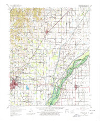
1958 Map of Marmaduke
USGS Topo · Published 1980About this map
The St Louis Southwestern Railway, known locally as the Cotton Belt, serves as the primary spine for this 1958 landscape, connecting the agricultural hubs of Marmaduke and Paragould. The terrain is defined by an intricate network of drainage canals and sloughs, such as St Francis River and Seneca Ditch, which transformed the bottomlands along the Arkansas-Missouri border into productive farmland. Numerous named islands, including Indian Hill Island and Upper Panther Island, signify the complex hydrology of the region before modern drainage fully reshaped the river system.
Find a feature on this map
90 named features on this map. Tap any name to fly to it.
Don’t see what you’re looking for? This feature index may not catch every label — zoom into the map to look around manually.
Map Details
Editions of this 1958 Marmaduke Map
2 editions found

Other maps of this area

1934 · Kennett
USGS Topo · 1:62,500

1935 · Rector
USGS Topo · 1:62,500

1935 · Knobel
USGS Topo · 1:62,500

1939 · Jonesboro
USGS Topo · 1:62,500

1940 · Gainesville
USGS Topo · 1:62,500

1940 · Marmaduke
USGS Topo · 1:62,500

1940 · Kennett
USGS Topo · 1:62,500

1940 · Piggott
USGS Topo · 1:62,500

1941 · Leachville
USGS Topo · 1:62,500

1941 · Manila
USGS Topo · 1:62,500