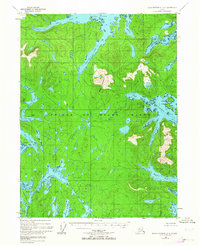
1948 Map of Dixon Entrance D-1
USGS Topo · Published 1964About this map
Prince of Wales Island presents a rugged and complex shoreline along the southern reaches of the Tongass National Forest. The landscape is dominated by the deep inlets of Moira Sound, including the West Arm and South Arm, which carve into the timbered interior. Evidence of early 20th-century coastal industry is visible at the Cannery (Aband) near Hunter Bay, a remnant of the region's salmon-packing history. To the east, Bokan Mountain rises as a prominent landmark above Perkins Creek. The intricate network of waterways like Hessa Narrows, McLean Arm, and Kendrick Bay reflects a maritime economy where travel and trade were entirely dependent on the tides and sheltered harbors of the Alexander Archipelago.
Find a feature on this map
33 named features on this map. Tap any name to fly to it.
Don’t see what you’re looking for? This feature index may not catch every label — zoom into the map to look around manually.
Map Details
Editions of this 1948 Dixon Entrance D-1 Map
2 editions found
Other maps of this area

1948 · Dixon Entrance D-2
USGS Topo · 1:63,360

1948 · Prince Rupert D-6
USGS Topo · 1:63,360

1948 · Dixon Entrance C-1
USGS Topo · 1:63,360

1948 · Ketchikan A-6
USGS Topo · 1:63,360

1948 · Craig A-1
USGS Topo · 1:63,360

1948 · Dixon Entrance D-1
USGS Topo · 1:63,360

1948 · Craig A-2
USGS Topo · 1:63,360

1951 · Prince Rupert
USGS Topo · 1:250,000

1951 · Dixon Entrance
USGS Topo · 1:250,000

1951 · Dixon Entrance D-2
USGS Topo · 1:63,360