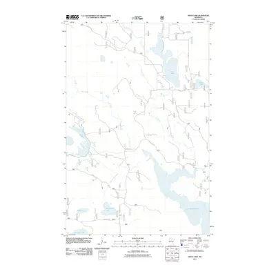
2011 Map of Dixon Lake
USGS Topo · Published 2011About this map
Lake Winnibigoshish dominates the southeastern corner of this northern Minnesota landscape, where the Third River flows through a complex network of wetlands and smaller basins. This 2011 survey by the U.S. Geological Survey illustrates a region defined by its hydrography and an extensive system of forest roads. The terrain is characterized by numerous glacial lakes, including the centrally located Minisogama Lake and the western Morph Lake. Transportation across this watery geography relies on a web of timber and access routes such as Forest Rd 2171 and Old County 35. The map provides a detailed view of the drainage patterns where Castle Creek and Crane Creek feed into the larger river system, reflecting the area's role as part of a significant freshwater ecosystem. Notable smaller bodies like Bog Lake and Kenogama Lake further underscore the saturated nature of the local environment.
Find a feature on this map
22 named features on this map. Tap any name to fly to it.
Don’t see what you’re looking for? This feature index may not catch every label — zoom into the map to look around manually.
Map Details
Editions of this 2011 Dixon Lake Map
This is the sole edition of this map. No revisions or reprints were ever made.
Other maps of this area

1919 · Rosy
USGS Topo · 1:62,500

1919 · Max
USGS Topo · 1:62,500

1954 · Bemidji
USGS Topo · 1:250,000

1957 · Bemidji
USGS Topo · 1:250,000

1958 · Bemidji
USGS Topo · 1:250,000

1971 · Squaw Lake
USGS Topo · 1:24,000

1971 · Dixon Lake
USGS Topo · 1:24,000

1971 · Gimmer Lake
USGS Topo · 1:24,000

1971 · Raven Lake
USGS Topo · 1:24,000

1971 · Decker Lake
USGS Topo · 1:24,000