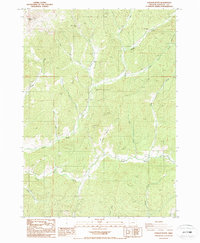
1987 Map of Dodson Butte
USGS Topo · Published 1987About this map
Dodson Butte rises as a prominent landmark in this drainage-heavy landscape of Douglas County, mapped during the late 1980s. The area is defined by the convergence of numerous named waterways, most notably North Myrtle Creek and South Myrtle Creek, which carve deep valleys through the timbered terrain. This map reveals a landscape primarily dedicated to resource extraction and local recreation, evidenced by the Frozen Creek Mine and the North Myrtle Creek Park. Local history is embedded in the nomenclature of the land, from the descriptive School Hollow to the utilitarian Borrow Pit. A dense network of smaller tributaries like Big Lick Creek, Bilger Creek, and Slide Creek illustrates the complex hydrology of this part of the Oregon Coast Range before more modern developments altered these remote watersheds.
Find a feature on this map
21 named features on this map. Tap any name to fly to it.
Don’t see what you’re looking for? This feature index may not catch every label — zoom into the map to look around manually.
Map Details
Editions of this 1987 Dodson Butte Map
This is the sole edition of this map. No revisions or reprints were ever made.
Other maps of this area

1897 · Roseburg
USGS Topo · 1:125,000

1900 · Roseburg
USGS Topo · 1:125,000

1904 · Riddle
USGS Topo · 1:125,000

1954 · Dixonville
USGS Topo · 1:62,500

1954 · Days Creek
USGS Topo · 1:62,500

1954 · Canyonville
USGS Topo · 1:62,500

1955 · Roseburg
USGS Topo · 1:62,500

1955 · Medford
USGS Topo · 1:250,000

1957 · Medford
USGS Topo · 1:250,000

1958 · Medford
USGS Topo · 1:250,000