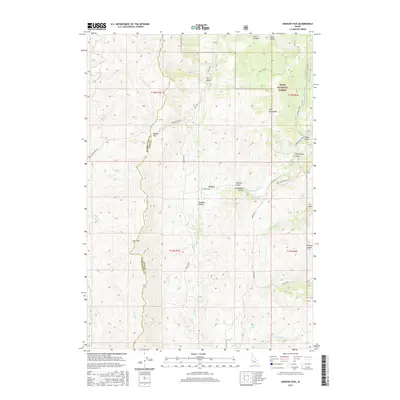
2017 Map of Dodson Pass
USGS Topo · Published 2017About this map
The settlement of Gross sits at the heart of this Gem County terrain, positioned where Nesbitt LN meets the drainage of Squaw Cr. The landscape is defined by the high divides between Gem and Washington Counties, marked by notable crossings such as Dodson Pass and Low Pass. This high-country region is characterized by a complex network of seasonal drainages and springs that feed into larger watercourses, including the Second Fork Squaw Cr and Cottonwood Cr.
Find a feature on this map
38 named features on this map. Tap any name to fly to it.
Don’t see what you’re looking for? This feature index may not catch every label — zoom into the map to look around manually.
Map Details
Editions of this 2017 Dodson Pass Map
This is the sole edition of this map. No revisions or reprints were ever made.
Other maps of this area

1894 · Squaw Creek
USGS Topo · 1:125,000

1953 · Smiths Ferry
USGS Topo · 1:62,500

1953 · Banks
USGS Topo · 1:62,500

1955 · Baker
USGS Topo · 1:250,000

1959 · Baker
USGS Topo · 1:250,000

1970 · Dodson Pass
USGS Topo · 1:24,000
1970 · Coonrod Gulch
USGS Topo · 1:24,000

1970 · Granger Butte
USGS Topo · 1:24,000
1970 · Ola
USGS Topo · 1:24,000
1970 · Riley Butte
USGS Topo · 1:24,000