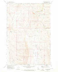
1970 Map of Riley Butte
USGS Topo · Published 1974About this map
Riley Butte dominates the northern horizon of this Washington County landscape, which transitions from high ridges to the broad expanse of Big Flat. In the early 1970s, this area remained largely defined by traditional land use and a sparse network of mountain roads. The Boise Meridian runs vertically through the eastern portion of the map, serving as a critical survey marker for Idaho's early land claims. Family history is centered around the Walker Cem and the naming of local landmarks such as Tennison Ridge, reflecting the early settlers who managed the rugged terrain. Transportation is limited to functional routes like Mc Faddan Lane and various unnamed tracks that navigate the drainages of North Crane Creek and Sheep Creek. This geography reveals a landscape where water sources, often simply labeled Spring, were the primary anchors for homesteading and grazing.
Find a feature on this map
18 named features on this map. Tap any name to fly to it.
Don’t see what you’re looking for? This feature index may not catch every label — zoom into the map to look around manually.
Map Details
Editions of this 1970 Riley Butte Map
This is the sole edition of this map. No revisions or reprints were ever made.
Other maps of this area

1894 · Squaw Creek
USGS Topo · 1:125,000

1897 · Weiser
USGS Topo · 1:125,000

1955 · Baker
USGS Topo · 1:250,000

1957 · Crane Creek Reservoir
USGS Topo · 1:62,500

1959 · Baker
USGS Topo · 1:250,000

1970 · Dodson Pass
USGS Topo · 1:24,000
1970 · Paddock Valley Reservoir
USGS Topo · 1:24,000
1970 · Coonrod Gulch
USGS Topo · 1:24,000

1970 · Granger Butte
USGS Topo · 1:24,000
1970 · Ola
USGS Topo · 1:24,000