
1935 Map of Doe Mountain
USGS Topo · Published 1935About this map
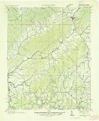
Mountain City serves as the primary hub in this mountainous corner of Tennessee, situated where Roan Creek and several mountain ridges converge. This 1935 field examination by the Tennessee Valley Authority captures the region before the creation of Watauga Lake, showing the original location of Butler and the Watauga Academy along the riverbanks. The map illustrates a landscape of dispersed agricultural communities like Elk Mills and Neva, each anchored by local institutions such as Shouns Chapel Sch and Mount Gilead Ch. The terrain is dominated by the massive Iron Mountains and Doe Mountain, with the Cherokee National Forest boundary carving through the high ridges. This survey provides a critical record of the valley floor's road network, including State Highway 67, and early post offices like Vaughtsville P O that served remote mountain coves.
Find a feature on this map
78 named features on this map. Tap any name to fly to it.
Don’t see what you’re looking for? This feature index may not catch every label — zoom into the map to look around manually.
Map Details
Editions of this 1935 Doe Mountain Map
2 editions found
Other maps of this area

1891 · Roan Mountain
USGS Topo · 1:125,000

1891 · Abingdon
USGS Topo · 1:125,000

1893 · Cranberry
USGS Topo · 1:125,000

1894 · Roan Mountain
USGS Topo · 1:125,000

1894 · Abingdon
USGS Topo · 1:125,000

1895 · Cranberry
USGS Topo · 1:125,000

1897 · Bristol
USGS Topo · 1:125,000

1899 · Cranberry
USGS Topo · 1:125,000

1902 · Bristol
USGS Topo · 1:125,000

1902 · Cranberry
USGS Topo · 1:125,000