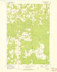
1973 Map of Doering
USGS Topo · Published 1976About this map
Doering and the surrounding townships of Schley, Vilas, Pine River, and Ackley reveal a landscape defined by Northwoods timber history and water management in the early 1970s. An Old Railroad Grade and Old Grade wind through the terrain, tracing the paths of former logging lines that once moved forest products through this region. The northern section is punctuated by a Fish Hatchery and numerous small watercourses like the North Branch Pine River and McCloud Creek.
Find a feature on this map
38 named features on this map. Tap any name to fly to it.
Don’t see what you’re looking for? This feature index may not catch every label — zoom into the map to look around manually.
Map Details
Editions of this 1973 Doering Map
This is the sole edition of this map. No revisions or reprints were ever made.
Other maps of this area

1899 · Wausau
USGS Topo · 1:125,000

1902 · Wausau
USGS Topo · 1:125,000

1940 · Parrish
USGS Topo · 1:48,000

1950 · Parrish
USGS Topo · 1:48,000

1950 · Tomahawk
USGS Topo · 1:48,000

1951 · Doering
USGS Topo · 1:48,000

1951 · Merrill
USGS Topo · 1:48,000

1952 · Parrish
USGS Topo · 1:48,000

1952 · Tomahawk
USGS Topo · 1:48,000

1954 · Iron Mountain
USGS Topo · 1:250,000