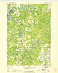
1950 Map of Tomahawk
USGS Topo · Published 1956About this map
Tomahawk and the surrounding riverine landscape of Lincoln County are defined by the winding course of the Wisconsin River during the mid-century. The river's industrial and hydro-electric utility is evident through structures like Kings Dam and Grandmother Dam, which helped create large reservoirs such as Lake Mohawksin. This era shows a network of local transport and communication, including the Chicago Milwaukee St Paul and Pacific railroad and a Radio Station near Irma. Beyond the industrial centers, the landscape is dotted with numerous lakes like Perch Lake and Copper Lake, interspersed with rural institutions such as the Clover Belt School and Oak Hill Cemetery. The presence of several schools marked as abandoned, such as Bass Lake School and Dotter School, suggests a period of rural consolidation as smaller communities like Gleason and Bloomville served as the primary local hubs.
Find a feature on this map
101 named features on this map. Tap any name to fly to it.
Don’t see what you’re looking for? This feature index may not catch every label — zoom into the map to look around manually.
Map Details
Editions of this 1950 Tomahawk Map
This is the sole edition of this map. No revisions or reprints were ever made.
Other maps of this area

1899 · Wausau
USGS Topo · 1:125,000

1902 · Wausau
USGS Topo · 1:125,000

1902 · Marathon
USGS Topo · 1:125,000

1939 · Mc Cord
USGS Topo · 1:48,000

1939 · Cassian
USGS Topo · 1:48,000

1940 · Parrish
USGS Topo · 1:48,000

1940 · Rhinelander
USGS Topo · 1:48,000

1942 · Cassian
USGS Topo · 1:48,000

1947 · Mc Cord
USGS Topo · 1:48,000
1949 · Rhinelander
USGS Topo · 1:48,000