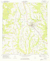
1974 Map of Doerun
USGS Topo · Published 1976About this map
The Georgia Northern railroad forms the industrial backbone of this South Georgia landscape, passing directly through the community of Doerun and connecting the rural outposts of Ticknor and Pritchetts. Along this corridor, the transition from Colquitt to Worth and Mitchell counties is marked by a steady rhythm of family-named landmarks and rural institutions. Significant genealogical sites are scattered across the terrain, including Smith Cem, Duncan Smith Cem, and Pitts Cem, while educational history is preserved at the Hillcrest Sch. The eastern edge of the map is defined by the Ochlockonee River, which creates a natural boundary against the more developed grid of the town center. Local spiritual life is well-documented with numerous houses of worship such as Liberty Hill Ch, New Light Ch, and Cool Springs Ch serving the outlying farmsteads.
Find a feature on this map
28 named features on this map. Tap any name to fly to it.
Don’t see what you’re looking for? This feature index may not catch every label — zoom into the map to look around manually.
Map Details
Editions of this 1974 Doerun Map
This is the sole edition of this map. No revisions or reprints were ever made.
Other maps of this area

1953 · Dothan
USGS Topo · 1:250,000

1953 · Waycross
USGS Topo · 1:250,000

1954 · Dothan
USGS Topo · 1:250,000

1955 · Dothan
USGS Topo · 1:250,000

1956 · Baconton
USGS Topo · 1:62,500

1956 · Doerun
USGS Topo · 1:62,500

1958 · Waycross
USGS Topo · 1:250,000

1971 · Cotton
USGS Topo · 1:24,000
1974 · Putney
USGS Topo · 1:24,000
1974 · Tempy
USGS Topo · 1:24,000