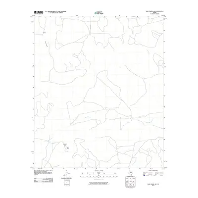
2010 Map of Dog Creek NW
USGS Topo · Published 2010About this map
McClure Ranch and the Alvie Cole Ranch anchor this West Texas landscape, reflecting a region defined by extensive landholdings and private aviation. The terrain is shaped by the drainage patterns of Mulberry Creek and its tributary Little Mulberry Creek, which cut through the open country. To the north, Coyote Creek and James Hollow mark the varying elevations of the Sterling County ranchlands. Connectivity across these properties is maintained by a network of ranch roads and local routes, including Fm 2034 and Co Rd 116-p. The presence of the Alvie Cole Ranch Airport highlights the practical reliance on air travel in managing such large-scale agricultural operations. This survey provides a clear view of the mid-2000s ranching infrastructure, capturing the intersection of traditional land use and modern transportation.
Find a feature on this map
10 named features on this map. Tap any name to fly to it.
Don’t see what you’re looking for? This feature index may not catch every label — zoom into the map to look around manually.
Map Details
Editions of this 2010 Dog Creek NW Map
This is the sole edition of this map. No revisions or reprints were ever made.
Other maps of this area

1954 · San Angelo
USGS Topo · 1:250,000

1958 · San Angelo
USGS Topo · 1:250,000

1963 · Cumbie Draw
USGS Topo · 1:24,000

1965 · San Angelo
USGS Topo · 1:250,000

1972 · Sterling City
USGS Topo · 1:24,000

1972 · Dog Creek NE
USGS Topo · 1:24,000

1972 · Dog Creek SW
USGS Topo · 1:24,000

1972 · Broome
USGS Topo · 1:24,000

1972 · Dog Creek NW
USGS Topo · 1:24,000
1972 · Dog Creek
USGS Topo · 1:24,000