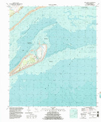
1994 Map of Dog Island
USGS Topo · Published 1998About this map
Dog Island stands as a distinct barrier between the Gulf of Mexico and the protected waters of Saint George Sound in this 1990s bathymetric-topographic study. The map documents a landscape defined by shifting sands and maritime access, featuring the small Dog Island Airstrip and the sheltered basin of Tysons Harbor on the island's leeward side. Beyond the land, the survey provides extensive underwater depth contours, noting that much of the surrounding seabed is an area subject to frequent change. To the north and east, the protected waters of the Alligator Harbor State Aquatic Preserve and the long stretch of Lanark Reef illustrate the complex coastal ecology of Franklin County before the turn of the twenty-first century. A Ferry route connects the island to the mainland, emphasizing its isolation and reliance on waterborne transport.
Find a feature on this map
11 named features on this map. Tap any name to fly to it.
Don’t see what you’re looking for? This feature index may not catch every label — zoom into the map to look around manually.
Map Details
Editions of this 1994 Dog Island Map
This is the sole edition of this map. No revisions or reprints were ever made.
Other maps of this area

1943 · Dog Island
USGS Topo · 1:31,680

1943 · Carrabelle
USGS Topo · 1:24,000

1943 · St. Teresa Beach
USGS Topo · 1:24,000

1944 · Pickett Bay
USGS Topo · 1:31,680

1944 · Carrabelle
USGS Topo · 1:31,680

1944 · Sugar Hill
USGS Topo · 1:31,680

1945 · Mc Intyre
USGS Topo · 1:31,680

1945 · Sugar Hill
USGS Topo · 1:31,680

1945 · St Teresa
USGS Topo · 1:31,680

1945 · Pickett Bay
USGS Topo · 1:31,680