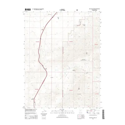
2014 Map of Dog Valley Peak
USGS Topo · Published 2014About this map
Dog Valley Peak and the high ridges of the Pahvant Range dominate this 2014 survey of the Fishlake National Forest in central Utah. The landscape is defined by steep verticality, dropping from mountain summits into deep drainages like Widemouth Canyon and Baker Canyon. The southern portion of the map centers on the high-altitude Dog Valley, where the ephemeral waters of Dog Valley Cr navigate through tight terrain at The Narrows. A primary north-south transportation corridor skirts the western edge of the mountains, following the natural grade of the Cove Fort Dog Valley Pass. To the north, the terrain levels out into the broad expanse of White Sage Flat, accessible via the solitary Horse Hollow Rd. The map provides a precise look at modern forest boundaries and public land survey systems across this transition from flat basin to high peak.
Find a feature on this map
27 named features on this map. Tap any name to fly to it.
Don’t see what you’re looking for? This feature index may not catch every label — zoom into the map to look around manually.
Map Details
Editions of this 2014 Dog Valley Peak Map
This is the sole edition of this map. No revisions or reprints were ever made.
Other maps of this area

1885 · Beaver
USGS Topo · 1:250,000

1932 · Sevier
USGS Topo · 1:62,500

1935 · Sevier
USGS Topo · 1:62,500

1953 · Richfield
USGS Topo · 1:250,000

1958 · Richfield
USGS Topo · 1:250,000

1962 · Fillmore
USGS Topo · 1:62,500

1962 · Tabernacle Hill
USGS Topo · 1:62,500

1962 · Cove Fort
USGS Topo · 1:62,500

1980 · Richfield
USGS Topo · 1:100,000
1981 · Red Ridge
USGS Topo · 1:24,000